 Početkom marta 2012, Rockefeller Brothers Fund (RBF) je odobrila finansiranje novog projekta Expeditio pod nazivom "Promocija principa održivog razvoja u javnim prostorima Boke Kotorske". Projekat će trajati dvije godine, a u nastavku možete pročitati ciljeve i očekivane rezultate. Uključivanje različitih aktera koje zanimaju javni prostori biće veoma važna komponenta ovog projekta, te se nadamo da će postojati zainteresovanost za saradnju.
About the project
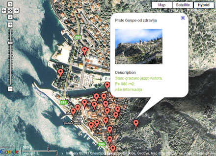
During 2011, through an EU-funded project entitled SOSTENUTO, Expeditio realized an activity that included the mapping of around 177 public spaces in Boka Kotorska region. We took in account that these places could be utilized in a better way, i.e. that they have the potential to become the areas of public interest. The mapping was done in the three municipalities of Boka Kotorska - Kotor, Tivat and Herceg Novi. During the mapping process, the following public spaces have been identified:
- Spaces that are currently used, but have the potential to be utilized in a better way, i.e. to attract people to spend more time in them;
- Spaces that are not currently used (or are used for inadequate purposes), although they have the potential to be used as area of public interest;
One of the conclusions of the mapping process is that large areas of public spaces in Boka Kotorska region have potential for different public activities (various social and cultural events), but they are not utilized in a proper way. Some of these spaces are physically unattractive because of neglect and general poor state in which they are currently. Some are insufficiently equipped – without sitting places, greenery, lighting, etc. Furthermore, some public spaces are difficult to access. In such situation, possible areas and centres for gathering of citizens and tourists remain unnoticed and unused, or their beauty cannot be easily perceived. Very often, such spaces are exposed to negligence and turned into parking lots, sites for disposal of unneeded items, etc.
The “Mapping of public spaces” activity did not include any concrete field interventions (installing pieces of street furniture, reconstruction, activities with citizens, etc.). At that stage, it only implied identification of the potentials of spaces to become better utilized in public interest. A starting methodology for the assessment of public spaces was taken from the document “ACHIEVING GREAT FEDERAL PUBLIC SPACES: A PROPERTY MANAGER’S GUIDE” http://www.pps.org/projects/propertymanagersguide/ .
A map of public spaces in Boka Kotorska was placed on-line, with an invitation to citizens to supplement it. The map can be viewed at http://www.strategija.bokabay.info
Aim of the project
The aim of the project “Promoting the Principles of Sustainable Development in Public Spaces of Boka Kotorska” is to implement various interventions in some of the public spaces identified through the realized process of “Mapping of public spaces”, making them, in that way, experimental fields for promoting sustainable development ideas.
Expected results
1. Realized interventions in three neglected public spaces in Boka Kotorska through concrete activities that reflect the principles of sustainable development;
2. Developed model for promoting sustainable development principles in public spaces that can be used for other communities/public spaces in Montenegro;
3. Increased level of education of citizens on sustainable development through activities in public spaces of Boka Kotorska and through promoting good practices examples;
Duration: 2 years
Budget: 50.000,00 $